Project 1: Volcano Deformation Survey over the Northern and Central Andes with ALOS InSAR Time Series Analysis
|
Published in: Geochemistry, Geophysics, Geosystems (An AGU journal; See CV)
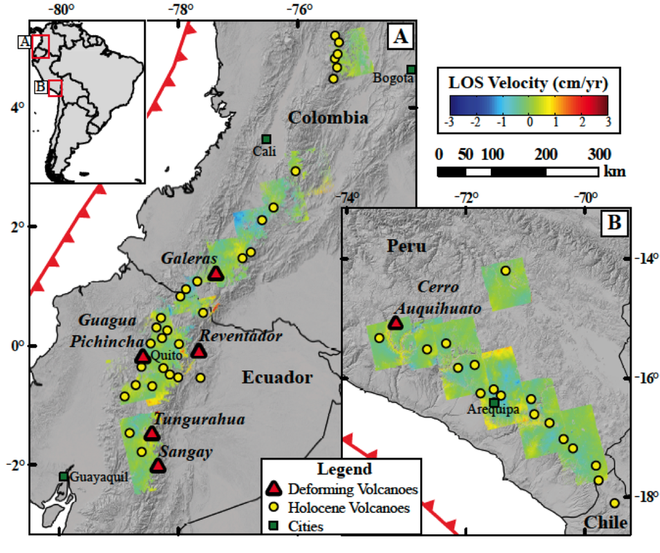
Abstract - We use ALOS-1 Interferometric Synthetic Aperture Radar data spanning the period of 2007–2011 to obtain time-dependent ground deformation data over all of the volcanoes in Colombia, Ecuador, and Peru. We detect deformation on or near the proximity of Galeras, Reventador, Tungurahua, Guagua Pichincha, Sangay, and Cerro Auquihuato volcanoes, uncovering previously undocumented deformation in the latter three. Deformation is attributed to changes in pressurization of the volcanic systems (Galeras, Tungurahua, Guagua Pichincha, and Cerro Auquihuato), subsidence associated with flow deposits (Reventador), and flank creep (Sangay). Our models suggest that the pressure sources are located at depths of ∼1–6 km from the surface, indicating that the measurable deformation within our data is restricted to shallow magma chambers and hydrothermal systems. |
|
Project 2: Ground deformation before the 2015 eruptions of Cotopaxi volcano detected by InSAR
Published in: Geophysical Research Letters (An AGU journal; See CV)
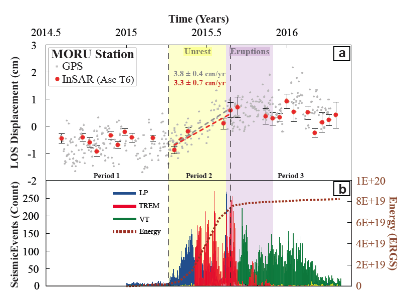
Abstract - Cotopaxi volcano started a period of volcanic unrest in April 2015 that led to a series of eruptions between August and November 2015. We use COSMO-SkyMed Interferometric Synthetic Aperture Radar supported by Continuous GPS observations spanning the period of 2014-2016 to obtain time-dependent ground deformation data over Cotopaxi volcano related to the period of unrest and onset of eruptions. We find evidence of precursory deformation, with a maximum uplift on the western flank of 3.4 cm from April to August 2015. Deformation is explained by an inclined sheet intrusion located a few km southwest of the summit with an opening volume of 6.8 x 10⁶ m3, extending from a depth of 12.1 km and shallowing to 5.5 km below the summit, that contributed to internal edifice growth. The temporal coincidence of deformation prior to the eruptions potentially suggests that short-term eruptions at Cotopaxi are partly controlled by episodic edifice growth.
Published in: Geophysical Research Letters (An AGU journal; See CV)
Abstract - Cotopaxi volcano started a period of volcanic unrest in April 2015 that led to a series of eruptions between August and November 2015. We use COSMO-SkyMed Interferometric Synthetic Aperture Radar supported by Continuous GPS observations spanning the period of 2014-2016 to obtain time-dependent ground deformation data over Cotopaxi volcano related to the period of unrest and onset of eruptions. We find evidence of precursory deformation, with a maximum uplift on the western flank of 3.4 cm from April to August 2015. Deformation is explained by an inclined sheet intrusion located a few km southwest of the summit with an opening volume of 6.8 x 10⁶ m3, extending from a depth of 12.1 km and shallowing to 5.5 km below the summit, that contributed to internal edifice growth. The temporal coincidence of deformation prior to the eruptions potentially suggests that short-term eruptions at Cotopaxi are partly controlled by episodic edifice growth.
Project 3: Volcano deformation survey in the Philippines using ALOS InSAR time-series analysis
|
Published in: Proceedings of the Fringe 2015 Workshop (European Space Agency Publications Division; See CV)
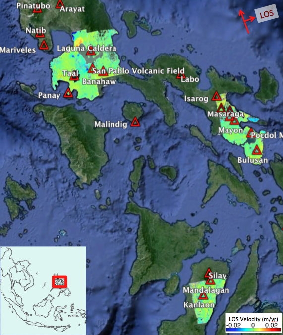
Summary Bulusan, Kanlaon, and Mayon volcanoes have erupted over the last decade, and Taal caldera showed signs of volcanic unrest within the same time range. Eruptions at these volcanoes are a threat to human life and infrastructure, having over 1,000,000 people living within 10 km from just these 4 volcanic centers. For this reason, volcano monitoring in the Philippines is of extreme importance. We use the ALOS-1 satellite from the Japanese Aerospace Exploration Agency (JAXA) to make an InSAR time series analysis over Bulusan, Kanlaon, Mayon, and Taal volcanoes for the 2007-2011 period. Time-dependent deformation was detected at all of the volcanoes. Deformation related to changes in pressurization of the volcanic systems was found on Taal caldera and Bulusan volcanoes, with best fitting Mogi sources located at half-space depths of 3.07 km and 0.5 km respectively. |
|
|
Project 4: Thermo-mechanical volcano deformation models from finite element methods
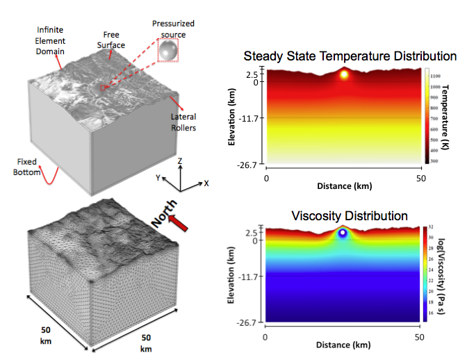
Summary - Volcanic deformation studies typically present first order estimates of magmatic source characteristics using elastic, homogeneous, isotropic half-space models. However these assumptions are unrealistic representations of the subsurface and can yield erroneous results. Subsurface rocks in volcanically active regions are significantly heated, and thus viscoelastic effects are more applicable. We build finite element models that account for topography and mechanically heterogeneous subsurface properties. We include the influence of temperature-dependent viscosity, η, calculated using the Arrhenius formulation (Tungurahua volcano example on the right). |
|
Using Seismic Tomography to obtain mechanical properties
|
IGEPN 1-D seismic velocity from RENSIG (Font et al., 2013): 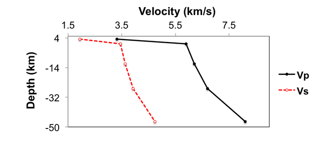
|
Elastic Properties from Vp and Vs (Brocher, 2005),
for 1.5km/s < Vp < 8.5km/s: 


|
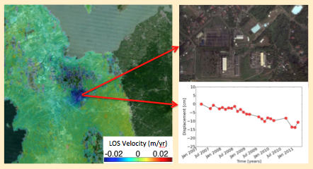
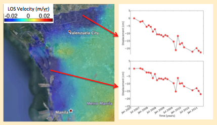
Project 5: Land subsidence in the Philippines using ALOS InSAR time-series analysis
|
Bulalo Geothermal Field example (Figure below): Subsidence at an average rate of ~3 cm/yr, related to groundwater withdrawal for geothermal energy development
|
Several cities in Philippines show subsidence due to excessive groundwater extraction, in this example at a maximum average rate of 6 cm/yr (See Figure below)
|
|
|
